Bennington; Bennington County 425 Acres
For more information about this unit please visit the web page:
General Description:
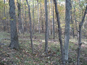
The 425-acre Whipstock Hill Wildlife Management Area (WMA) is located in the Vermont Valley biophysical region in the southwestern Vermont town of Bennington adjacent to the New York state border. The WMA consists of two parcels physically divided by Whipstock Road. The main parcel is the western-most and largest and is located between Whipstock Road and Vermont Route 279. The smaller parcel is located east of Whipstock Road and is dominated by wetlands.
Unique Features:
Twelve natural communities were identified on the WMA including three rare communities (Rich Fen, Wet Clayplain Forest and Mesic Clayplain Forest) and four uncommon communities (Calcareous Red Maple-Tamarack Swamp, Silver Maple-Sensitive Fern Riverine Floodplain Forest, Dry Oak-Hickory-Hophornbeam Forest and Mesic Maple-Ash-Hickory-Oak Forest). Based on community quality and rarity, the Rich Fen and Wet and Mesic Clayplain Forests are considered state significant.
Recreation Overview:
Recreational uses are dominated by dispersed, non-motorized, fish and wildlife-based activities including hunting, fishing, trapping, hiking, snowshoeing, and wildlife viewing. There are no designated trails within the WMA, however, there are existing woods roads on moderate terrain that provide non-motorized access within the WMA.
- Information on hunting, fishing and trapping in Vermont
- Authorized and Prohibited Activities on Fish & Wildlife Lands
Planning Overview:
The long-range management plan for Whipstock Hill Wildlife Management Area was completed in 2016. The 425-acre WMA was acquired by the Vermont Fish and Wildlife Department in 2008. The WMA is made up of a combination of wetlands and forested uplands and is dominated by the 1260-foot Whipstock Hill.
Planning Updates: