Guilford; Windham County 100 Acres
For more information about this unit please visit the web page:
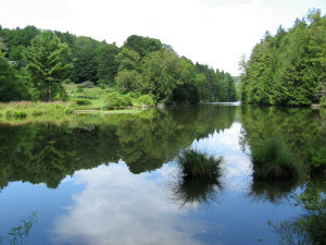
General Description:
Sweet Pond State Park was established in 1976 when the State of Vermont purchased a 100-acre tract of land with funds from the federal Land and Water Conservation Fund. The park is named after Dr. Charles and Susan Sweet, who maintained a summer home on the property for much of the 20th century. Located in the southeastern Vermont town of Guilford, the park is less than 1½ miles from the Massachusetts border, and is nine miles southwest of Brattleboro. The land was originally settled by the Franklin family, who farmed the land for more than 150 years beginning in 1777. The Franklin Cemetery lies within the park just west of the park entrance.
Unique Features:
The Sweet Pond dam rehabilitation project was completed in October, 2019 and the pond was refilled later that fall. The Guilford Historical Society has officially named it the Franklin Dam. A historical marker was installed that explains the history of the dam site. The Sweet Pond Trail has reopened with a bridge across Keets Brook 150 feet downstream of the dam.
Recreation Overview:
The park is undeveloped, except for the Sweet family homestead, a public parking area and a foot trail. There are traces of historic farmsteads and roads on the property. The 1.3 mile Sweet Pond Trail circumnavigates the pond. The park is managed for dispersed recreation, wildlife habitat and timber production. The park is open for day activities; camping or overnight use is not permitted. Hiking is the most common activity here.
- Sweet Pond State Park Map and Guide
- Sweet Pond Trail (Trail Finder)
- Information on hunting, fishing and trapping in Vermont
- Using State Lands for Recreation
- FPR Recreation Activities
Planning Overview:
The Long Range Management Plan (LRMP) for the Brattleboro Management Unit was developed in 2012.