Tinmouth; Rutland County 1,260 Acres
For more information about this unit please visit the web page:
General Description:
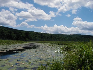
The 1,260-acre Tinmouth Channel Wildlife Management Area (WMA) is a mosaic of upland forests and wetlands dominated by a Class 1 wetland at its core. The WMA is made up of three parcels separated by roads. The main parcel, to the north, is the largest of the three. The Packard Mill Lot is located south of Route 140 and the Hoadley Mill Lot is south of Channel Road. The WMA is located within the Taconic Mountain Biophysical Region in the Town of Tinmouth in southwestern Vermont.
Unique Features:
Eighteen natural communities have been identified on the WMA including two rare communities (Rich Fen and Red Maple-Tamarack Swamp). There are also five uncommon wetland communities. Many of the natural communities on the WMA are typical of rich, relatively warm and dry places. The northern hardwood forest formation types found on the parcel have southern affinities, including oaks and hickories as well as more northern species.
Recreation Overview:
Recreational uses of the WMA are dominated by dispersed, non-motorized, fish and wildlife-based activities including hunting, fishing, trapping, hiking, wildlife viewing, canoeing, kayaking and snowshoeing. There are no designated trails within the WMA. However, there are existing woods roads on moderate terrain which provide non-motorized access within the WMA. Part of the appeal of Tinmouth Channel WMA for many recreationists is a sense of remoteness and wild character that is often absent in this part of Vermont.
- Information on hunting, fishing and trapping in Vermont
- Authorized and Prohibited Activities on Fish & Wildlife Lands
Planning Overview:
The long-range management plan for Tinmouth Channel WMA was developed in 2012.